24 kilometres of Himalayan trail from Ransi village to an ancient Panch Kedar shrine at 3,497 metres. Through old-growth forest, open meadow, and the full sweep of the Garhwal range — this is the trek Uttarakhand keeps quietly to itself.
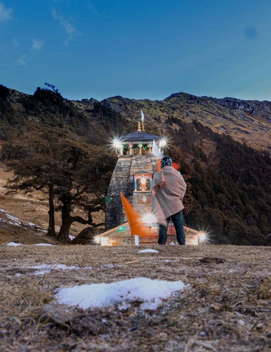
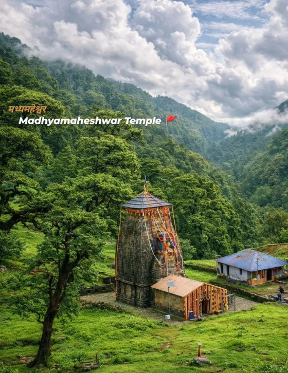
The Madmaheshwar trek — also called the Madhyamaheshwar trek — is a moderate Himalayan trail in the Rudraprayag district of Uttarakhand. The route begins at Ransi village (1,800m) near Ukhimath and travels 24 km through dense oak and rhododendron forest to Madmaheshwar temple at 3,497 metres — the second of the five sacred Panch Kedar shrines of Lord Shiva.
The trail passes entirely through the Kedarnath Wildlife Sanctuary. There are no roads, no cable cars, and no shortcuts. What greets you at the end is a stone temple older than memory, with Shivling (6,543m), Kedarnath (6,940m), and Chaukhamba (7,138m) watching from the horizon in every direction.
Unlike the busier Himalayan circuits, the Madmaheshwar trail stays quiet. The forest is ancient, the meadows are intact, and the peaks are as close as they have always been. This is one of Uttarakhand’s genuinely unspoiled treks — and it will stay that way only as long as people walk it with care.
From Ransi village to the temple at 3,497m — five stages across 24 km of Himalayan trail through the Kedarnath Wildlife Sanctuary.
The last point accessible by road. Forest entry checkpoint is here — show government ID, pay sanctuary fee. The trail begins across the Markanda stream bridge. Old-growth oak forest closes around you immediately.
A small shepherd settlement at 5 km from Ransi. A tea stall operates here in season — the last place to buy anything before the temple. The forest here is at its densest and most beautiful, rhododendrons blooming red in May.
Day 1 ends here. The forest thinning above 2,400m opens the first views of distant snow peaks. Gaundhar is a proper campsite with basic accommodation. The night sky at 2,600m with no light pollution is something to stay awake for.
After the steep forest climb from Gaundhar, the trail opens to an expansive open ridge with the Himalayan panorama ahead. The gradient eases here. The temple is visible on the ridge ahead. Shivling and Kedarnath fill the sky to the northwest.
Upper temple, 3 km above the main shrine. 360° unobstructed view — Shivling, Kedarnath, Chaukhamba, Satopanth and Neelkanth simultaneously visible. The finest mountain panorama on this route. Do not skip this.
Day by Day
5 days from Dehradun. Every day described so you know exactly what to expect from the moment you leave the city to the moment you return.
Depart Dehradun early — 5:00 AM to 6:00 AM is ideal. The 220-km drive to Ransi passes through Rishikesh, Devprayag (the confluence of the Alaknanda and Bhagirathi rivers — worth a 15-minute stop), Rudraprayag, and Ukhimath before climbing on a mountain road to Ransi village. The journey takes 7–8 hours with stops.
The last ATM is in Ukhimath town — withdraw all the cash you need here. From Ukhimath to Ransi is approximately 25 km (45 minutes). Arrive at Ransi by afternoon, check in to the guesthouse, meet your guide, confirm your gear list, and get to bed early. Tomorrow is the longest day.
Important: Mobile signal disappears within the first kilometre of the trail tomorrow. Before leaving Ransi in the morning, tell your emergency contacts your exact plan and return date.
Register at the forest entry checkpoint at the edge of Ransi village — show government ID and pay the Kedarnath Wildlife Sanctuary entry fee. The checkpoint opens at 7:00 AM. Cross the Markanda stream bridge and enter the forest. The trail is immediately clear and climbs steadily through dense oak. The forest is beautiful — old-growth trees with moss-covered roots, bird calls in every direction, filtered morning light through the canopy.
Bantoli appears at 5 km — a small shepherd settlement with a tea stall in season. Rest here, refill water, continue. The remaining 7 km to Gaundhar involve more climbing, a brief descent into a side valley, and a final push to the campsite. Arrive Gaundhar (2,600m) by 2:00 PM. The mountain views from the campsite begin here — distant snow peaks appearing above the ridgeline to the northwest. Night temperature: 6–10°C. Use your sleeping bag.
Tip: Start at a slower pace than feels necessary. The Day 1 forest section is the longest of the trek. Going steady for the first 2 hours preserves your energy for Gaundhar’s final approach.
The finest day of the Madmaheshwar trek. Leave after an early breakfast (6:00–6:30 AM). The trail from Gaundhar climbs steeply for the first 90 minutes through thinning birch and rhododendron forest. This is the hardest single section of the route — sustained, steep, and relentless. Take it slowly. There is no rush.
At roughly 3,200m the gradient eases and the forest opens. You emerge onto a high open ridge with the full Garhwal Himalayan range spread across the horizon. Shivling (6,543m), Kedarnath Peak (6,940m), and Chaukhamba (7,138m) stand together to the northwest, enormous and clear. The Madmaheshwar temple is visible on the ridge ahead. Continue across open terrain on a clear path. Reach the temple by early afternoon.
Attend the evening aarti at 6:00 PM. In the open air, at 3,497 metres, with the snow peaks turning gold in the last light — this is one of the most affecting experiences this region offers.
★ Day 2 Note: This day — the steep forest climb, the dramatic ridge opening, the Himalayan panorama, the temple approach — is consistently the most memorable day on any Uttarakhand trek. Start early. Do not rush the mountain views. Attend the aarti.
Attend the morning aarti at dawn (around 5:30–6:00 AM). After a slow breakfast, walk to Budha Madmaheshwar — the upper temple approximately 3 km above the main shrine at ~3,600 metres. The walk takes 1–1.5 hours each way on a clear trail. The gradient is moderate.
From Budha Madmaheshwar, the panoramic 360° view is completely unobstructed. Shivling fills the western sky. Kedarnath and Chaukhamba are visible simultaneously to the northwest. Satopanth (7,075m) glints in the northeast. Neelkanth (6,596m) rises to the south. This is one of the finest mountain panoramas accessible to ordinary trekkers in Uttarakhand — without technical climbing gear. Spend at least 45 minutes at the top.
Do not skip this: Almost every trekker who skips Budha Madmaheshwar regrets it. The 3 km walk is not difficult and the view from the upper temple is completely different from what you see at the main shrine.
Leave the temple after morning puja. The descent from the ridge in the early morning is quiet and unhurried. You know these peaks by name now. The morning often brings low cloud below the ridge that burns off by 9:00 AM to reveal the valley in sharp light. Take your time through the open section — the best photographs of the entire trek often come on the descent, when the urgency of reaching the temple is gone.
Descend through the forest to Gaundhar campsite, arriving by noon. Rest in the afternoon. Last night on the trail — sit outside after dinner if the sky allows.
Final morning. Depart after an early breakfast and descend the 12 km through forest to Ransi village — 4 hours. The trail you once entered as a stranger now feels entirely familiar. The forest is the same forest. You are not. Reach Ransi by noon, quick lunch, then the 7-hour drive back to Dehradun through Ukhimath, Rudraprayag, Devprayag, and Rishikesh. Mobile network returns at Ransi. The outside world reassembles itself around you on the drive home. Arrive Dehradun by evening.
Season Guide
The trek is open May to November. The best windows are May–June and September–October. Each season is a completely different experience.
★ Recommended
The last point accessible by road. Forest entry checkpoint is here — show government ID, pay sanctuary fee. The trail begins across the Markanda stream bridge. Old-growth oak forest closes around you immediately.
Not Recommended
The last point accessible by road. Forest entry checkpoint is here — show government ID, pay sanctuary fee. The trail begins across the Markanda stream bridge. Old-growth oak forest closes around you immediately.
★ Finest Views
The last point accessible by road. Forest entry checkpoint is here — show government ID, pay sanctuary fee. The trail begins across the Markanda stream bridge. Old-growth oak forest closes around you immediately.
Getting There
Drive to Ransi village — the trek starting point. It is the last motor road access before the 24-km trail begins.
| From | Distance | Drive Time | Route |
|---|---|---|---|
| Delhi | ~450 km | 10–11 hrs | Delhi → NH58/NH7 → Haridwar → Rishikesh → Devprayag → Srinagar → Rudraprayag → Ukhimath → Ransi Overnight halt recommended at Rishikesh |
| Dehradun | ~220 km | 7–8 hrs | Dehradun → Rishikesh → Devprayag → Rudraprayag → Ukhimath → Ransi Single day drive — depart by 5:00 AM for Ransi by afternoon |
| Haridwar | ~200 km | 6–7 hrs | Haridwar → Rishikesh → Devprayag → Rudraprayag → Ukhimath → Ransi |
| Rishikesh | ~170 km | 5–6 hrs | Rishikesh → Devprayag → Srinagar → Rudraprayag → Ukhimath → Ransi Morning departure recommended |
Nearest railway station: Rishikesh (170 km from Ransi). Regular trains from Delhi and Haridwar. From Rishikesh ISBT, morning buses depart for Ukhimath at 5:00–7:00 AM (6–7 hours). From Ukhimath, shared jeeps and taxis run to Ransi (25 km, 45 min).
Nearest airport: Jolly Grant Airport, Dehradun (220 km from Ransi). Regular flights from Delhi, Mumbai, Bangalore. From the airport, take a taxi or bus to Rishikesh, then onward toward Ukhimath. Flying in the evening before and driving the next morning works well.
Ukhimath is the last significant town before the trek — ATMs, pharmacies, shops, restaurants are all here. Ransi is 25 km from Ukhimath (45 min by shared jeep or taxi). Withdraw all cash in Ukhimath — there is no ATM at Ransi or on the trail.
Fitness & Difficulty
Rated Moderate. No technical climbing, no ropes. Suitable for beginners who prepare for 4–6 weeks beforehand.
What to Carry
Target pack weight: 8–12 kg. Your guide and porter carry group equipment. You carry personal gear.
❌ Do Not Carry
Alcohol (altitude + alcohol = increased AMS risk and poor judgment). Single-use plastic bottles (banned in Kedarnath Wildlife Sanctuary — bring a refillable bottle). Heavy camera tripods or body-only DSLR kits. Extra footwear beyond camp sandals. Anything you will not use. Every kilogram over 12 kg adds measurable difficulty to the Day 2 climb.
FAQ
Everything first-time trekkers ask us before booking. If your question isn’t answered here, WhatsApp us — we reply within 2 hours.
The Madmaheshwar trek distance is 24 km one way from Ransi village to the temple. The complete round trip is 48 km. If you include the optional Budha Madmaheshwar extension (3 km above the main temple), total trek distance becomes approximately 54 km. Most trekkers cover the full round trip over 4–5 days.
Madmaheshwar temple (also called Madhyamaheshwar temple) is located at 3,497 metres (11,473 feet) above sea level in Rudraprayag district, Uttarakhand. The trek starts at Ransi village (1,800m), meaning you gain 1,697 metres of elevation during the two-day ascent.
Yes — the Madmaheshwar trek difficulty is Moderate, making it suitable for beginners with adequate preparation. No technical climbing is required. With 4–6 weeks of preparation (regular walks, stair climbing, basic cardio) most people in average fitness can complete this route comfortably.
The best time to visit Madmaheshwar is May–June and September–October. May–June offers lush meadows, rhododendron blooms and warm days. September–October gives the clearest skies and finest mountain views of the year — many experienced trekkers consider October the finest month. Avoid July–August (heavy monsoon, slippery trail).
Ransi is 220 km from Dehradun (7–8 hours by road) via Rishikesh → Rudraprayag → Ukhimath → Ransi. From Delhi it is approximately 450 km (10–11 hours). Nearest railway station: Rishikesh. Nearest airport: Jolly Grant, Dehradun. From Ukhimath, shared jeeps and taxis run to Ransi (25 km, 45 min).
Not legally required, but strongly recommended. The trail passes through remote forest with no mobile network for most of the route. A certified local guide ensures safe navigation, emergency support, and knowledge of the trail, weather and local conditions. First-time trekkers should always trek with a guide. All our packages include a certified local guide from the villages along the route.
Budha Madmaheshwar (also called Vriddha Madmaheshwar) is the upper temple located approximately 3 km above the main Madmaheshwar temple at ~3,600 metres. The walk takes 1–1.5 hours each way. From there, the 360° panoramic view of Shivling, Kedarnath, Chaukhamba and Satopanth is completely unobstructed. Do not skip this — it is the finest mountain view on the entire trek.
Madmaheshwar temple opens on Akshaya Tritiya each year (typically April–May) and closes on Kartik Purnima (October–November). The exact 2026 opening date depends on the Hindu lunar calendar and is declared by the temple trust. Contact us — we track this and notify all registered trekkers as soon as the official date is announced.
